Barbados
A pictorial tribute to the Gem of the Caribbean.
All photos copyright Chris Alleyne.
Introduction
There is a rock in the south Caribbean, 90 miles to the east of the island chain, which was settled by the British in 1627. The rock had been visited 2 years earlier by Portuguese sailors who had christened it after the abundant bearded fig trees that grew there — ‘los barbadoes’ in Portuguese — but never actually settled by them.
The British claimed the island in the name of King Charles I and proceeded to build a settlement on the west coast near to a mangrove swamp.
Since then, Barbados has always been a British island — first as a colony — then, after Independence in 1966, as a fully-fledged member of the British Commonwealth. Many times since then, there has been talk about making the island a Republic, like its neighbour Trinidad & Tobago, but it has not yet happened.
Unlike the other Caribbean islands, Barbados is not in the Caribbean Sea, but actually lies at the western limit of the Atlantic Ocean. It is also a coral island, unlike its volcanic neighbours. These features are among those which made the island a strategic point and why for many years in the late 17th and early 18th century it was considered the jewel in Britain’s crown.
The collection of photos herein presented have been collected by the author since 2003, and have been compiled into two coffee-table books.

I have been photographing the Barbados landscape for close to 20 years. Considering that the island is only 166 square miles or about 430 square kilometres, I think I’ve covered most of it.
That is only the landscape. I've been playing with cameras for close to 60 years now, and recently I spend a lot of time asking myself ‘how did I get so old?’ Anyway, that answer is for me to work out.
Iwas raised mainly on the East Coast (of Barbados, that is), and sometimes it seems like there’s salt in my blood. it is, without a doubt, a special place in a very special place. We have problems. Who doesn’t these days? But an hour of clambering around the hills always set things right.

Some years ago, a rich foreigner invested I don’t know how much in the development of a bird sanctuary on the South Coast at the site of a mangrove swamp. The swamp used to have a sluice gate which was an ecological requirement to allow for the exchange of salt and brackish water for the mangroves to thrive. When the sluice gate ceased to function, and the administration of the time refused to take any action, The good gentleman packed his bags, took away his money and birds, and now we no longer have a Bird sanctuary.
This is what I mean when I say that we have issues! But, then again, everywhere has issues of some sort and, for me, those that we face are outweighed by the benefits of the lifestyle we live, although that too seems to be changing.


I made a presentation of my two books, ‘into the light’ and ‘almost Paradise’ to the National Collection at a public function in Bridgetown in April 2016 and, when the announcer called out the name of the second one, there was a murmur of ‘almost?’ in the crowd. It was quite entertaining.

In October 2010, Tropical Storm Tomas hit us with 100 MPH winds. It did not do serious damage, but it took care of this old house. I desaturated all colour except the green of the leaves and the magenta in the flowers to get this effect.
I had driven past this house several times, always intending to shoot this image. Weeks later, it was completely gone.
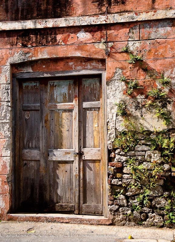
This old warehouse stood for years, slowly deteriorating until it was ‘renovated’, not restored. All of the historic charm is now gone, as is happening more and more these days.


The island is divided into 11 parishes. The total land area is 166 square miles, and the island is 21 miles wide by 14 at its widest point.
Many of the images shown here can be found in ‘almost Paradise’. Copies are available from the author at chrisalleyne.bb@gmail.com.


There are 3 out-of-service lighthouses around the island. Over the years, there have been several conversations with Government to allow private enterprise to take over the sites and restore them, at least to the point where the buildings could house restaurants or something similar. So far nothing has happened, and the structures continue to be unused.

IN the north of the island, overlooking the east coast is St. Nicholas Abbey. The plantation with its restored Jacobean house now has a sugar factory and a rum distillery where they grind cane and make their own rum. recently the owner, local architect Larry Warren and his family have built the Barbados Heritage Railway, which provides locals and visitors with a one-hour tour around the plantation grounds.

The view above encompasses almost the entire east coast of the island, from Morgan Lewis in the north to beyond Ragged Point towards the southern point of the island. The Heritage Railway mentioned earlier overlooks a similar vista at points along its journey.


Both of these boats were declared as derelict and destroyed.


This photo is from the top of the hills along the east coast. On the longest point, left of centre you can just make out the lighthouse at Ragged Point. It’s slightly less than halfway along the longest point.


Once you have spent time on the east coast it’s always in you. This photograph has been very popular among Barbadians who now live overseas.


It was difficult to time this photo; too early and the entire area was burnt out white with little detail, too late and there is not enough light to illuminate the scene.


I lived a few miles east of Speightstown, and the place was once painted in staid whites and greys. Then someone decided to change that and suddenly the buildings were all aqua, pale blue, pale magenta and yellow, adding a festive air. There is still little that goes on there compared to what it once was.
Several times in the past twenty years, various administrations have talked about adding a schooner ferry service from Bridgetown North but Speightstown still snoozes in the sun, waiting for something to happen.


Some years ago, the Garrison area in Barbados, which was where the British troops were stationed, was designated a World Heritage site. It boasts one of the largest cannon collections in the world, along with the Barbados Museum, which was once the military prison, and several barracks and administrative buildings from the eighteenth century.
At Cattlewash, where many local families used to vacation in the holiday months, houses are falling victim to the rot brought on by the salt air and a lack of attention. Some families still cling to the area as somewhere to live ut the cost of maintaining a property on the shore of the Atlantic continues to rise.

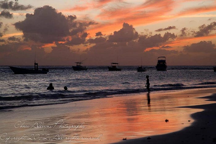
Here evening comes early, as the sun settles behind the hills in the late afternoon; the clouds take on a pinkish tinge, and it is usually dark thirty minutes to an hour before the Western parts of the island.

There’s lots more to come. Please come back.
